Hiding in Plain Sight: Is the Eye of the Sahara the Real Lost City of Atlantis?
For centuries, mainstream historians and archaeologists treated the story of Atlantis as a pure mythological allegory—a cautionary tale invented by the Greek philosopher Plato around 360 BCE to illustrate the dangers of imperial hubris. Those who did hunt for a physical location focused entirely on a sunken island swallowed by the waves of the Atlantic Ocean or the Mediterranean Sea.
However, alternative researchers approached the riddle from a different angle. They argued that if a global cataclysm—such as the Younger Dryas cosmic impact or the Great Deluge recorded by the Sumerians—occurred, Earth's geography would have shifted drastically. Ocean levels changed, landmasses rose, and what was once a coastal paradise might be sitting high and dry in the middle of a desert today.
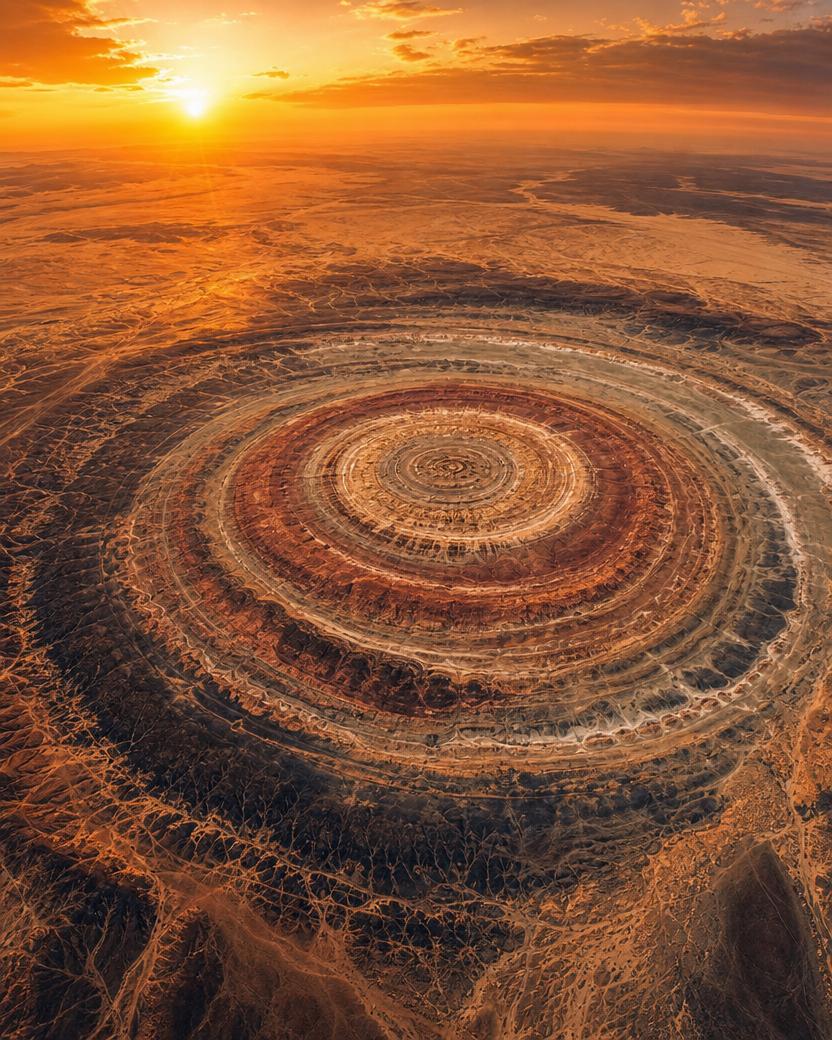
When satellites finally opened up our view of the planet from space, they revealed a breathtaking, mind-boggling anomaly hiding in the barren deserts of Mauritania, West Africa: The Richat Structure, also known as The Eye of the Sahara.
And when you lay Plato's ancient blueprints next to this 25-mile-wide circular phenomenon, the coincidences become too mathematically precise to ignore.
The Blueprint Comparison: Plato vs. The Richat Structure
Plato’s dialogues, Timaeus and Critias, provide highly specific geographical, geological, and dimensional clues about Atlantis. When mapped against the Eye of the Sahara, the data matches like a fingerprint:
- The Concentric Rings: Plato described Atlantis as a city engineered out of concentric rings—alternating circles of land and water (two of land, three of water). The Richat Structure is a massive, nested circular formation defined by distinct, concentric rock ridges that perfectly mirror this alternating ring design.
- The Exact Dimensions: According to Plato, the central island and its surrounding rings measured 127 stadia in diameter. In modern measurements, that translates to roughly 23.5 kilometers. Amazingly, high-resolution satellite measurements of the inner circular core of the Richat Structure clock in at almost exactly 23.5 kilometers.
- The Mountains to the North: The Greek dialogues explicitly state that the kingdom of Atlantis was sheltered by massive, majestic mountains to the north, which were celebrated for their beauty and rivers. The Richat Structure is bordered to the north by the towering, jagged ridges of the Adrar mountain plateau, which show clear signs of ancient, heavy water erosion paths.
- The Southern Sea Opening: Plato noted that the city opened up to the sea via a southern channel. The southern edge of the Richat Structure features a natural, broken topography where the ring walls flatten out, opening up directly toward the Atlantic coastal basin.
The Geology of a Myth
The correlations extend past basic geometry and dive straight into the physical composition of the dirt itself.
  Plato's Ancient Description               The Modern Richat Reality
 -----------------------------             ---------------------------
  • Black, red, and white stones            • Black basalt, red iron, white dacite
  • Abundant fresh water springs            • Massive underground aquifers
  • Copper and exotic metallurgy            • Rich local copper and gold deposits
Plato famously recorded that the Atlanteans quarried stones that were black, red, and white to construct their monumental buildings. Geologists surveying the Richat Structure have confirmed that the formation is packed with a unique, multi-colored volcanic layout: black basalt, iron-rich red rock, and white dacite stone.
Furthermore, the philosopher wrote that fresh water naturally welled up from the center ring of the city. While the Sahara is a hyper-arid desert today, modern hydrologists have mapped massive, ancient underground aquifers sitting directly beneath the center of the Richat Structure. The area was once a lush, water-rich oasis.
The Controversial Verdict
Mainstream geologists rigidly maintain that the Eye of the Sahara is entirely natural—a deeply eroded volcanic dome or "anticline" that buckled upward millions of years ago. They laugh off the Atlantis connection as a classic case of pareidolia, where people see patterns where none exist.
But the sheer volume of geographical, dimensional, and geological alignments continues to fuel a fierce debate. How did a philosopher writing 2,400 years ago, who had no access to satellites or global maps, describe a circular kingdom that perfectly matches an unmapped African anomaly down to the exact kilometer? The Eye of the Sahara stands as a staggering, visual reminder that our planet's deep history might be written in the sand, waiting for us to finally read it.
References
- Plato's Original Descriptions: Plato. Timaeus and Critias. Translated by Benjamin Jowett. Oxford University Press. (The foundational text detailing the dimensions, rings, and topography of Atlantis). Project Gutenberg Archive
- Geological Assessment of the Richat: Matton, G., Jébrak, M., & Lee, J. K. (2005). Resolving the Richat enigma: Doming and hydrothermal karstification, an alternative model. Journal of African Earth Sciences, 43(1-3), 291-302. ScienceDirect Link
- Sahara Paleoclimate and Hydrology: Drake, N. A., et al. (2011). Ancient watercourses and biogeography of the Sahara explain how Homo sapiens migrated out of Africa. Proceedings of the National Academy of Sciences (PNAS), 108(2), 458-462. (Proof of the lush, water-rich ancient history of the region). PNAS Journal
- Satellite and LiDAR Structural Overviews: European Space Agency (ESA). (2018). Earth From Space: The Eye of the Sahara. Copernicus Sentinel-2 Image Archive. ESA Portal