Believers in Atlantis, Lemuria and Mu hold that great continents once stood in the Atlantic, Indian and Pacific oceans, carried advanced civilizations, and sank, leaving myths, symbols and scattered peoples as their trace. Geologists and historians answer that each lost continent has a traceable author: Plato for Atlantis, a Victorian zoologist for Lemuria, a twentieth-century writer for Mu, and that plate tectonics explains the evidence those authors were trying to account for. The fight is between a story of sunken homelands and a record of how each idea entered print.
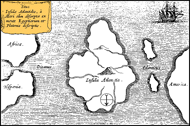
Atlantis begins with Plato. In the Timaeus, in W. R. M. Lamb's Loeb translation on the Perseus Digital Library (https://www.perseus.tufts.edu/hopper/text?doc=Perseus:text:1999.01.0180:text=Tim.:section=24e), an Egyptian priest tells Solon of a mighty host that advanced from a distant point in the Atlantic to attack Europe and Asia, and of an island beyond the pillars of Heracles "larger than Libya and Asia together," from which travellers could cross to other islands and to the opposite continent. The dialogue goes on to say the island was swallowed by the sea. Readers who take Atlantis as history point to the priestly records Plato invokes and to the detail of the account. Other readers stress that the account sits inside a philosophical dialogue, framed as a story told to Solon and retold across generations before Plato wrote it down. The text is the evidence for the story, and both sides begin with it.
Lemuria has a precise birth. In April 1864 the zoologist Philip Lutley Sclater published "The Mammals of Madagascar" in the Quarterly Journal of Science (https://archive.org/details/sim_journal-of-science_1864-04_1_2). Puzzled by the anomalies of Madagascar's mammals, and judging its lemurs "more nearly allied to the weaker forms of American monkeys" than to any Old World apes, he proposed that "a large continent occupied parts of the Atlantic and Indian Ocean," later broken into islands, with Madagascar and the Mascarenes as its relics, and wrote that for this continent, as the original focus of the lemurs, "I should propose the name Lemuria." His argument was explicitly conditional on the derivative origin of species, and it was a guess about animal distribution, not a claim about people.
Within a generation the name had a second life. Helena Petrovna Blavatsky's The Secret Doctrine, volume II, 1888 (https://archive.org/details/secretdoctrinesy02blav), adopted Lemuria as the third of five continents in a cosmic history of human races, credited the name to Sclater, dating his proposal to between 1850 and 1860, a few years before it appeared in print, and stretched the land from the Indian Ocean to Australia. In a footnote she conceded that Alfred Russel Wallace did not accept Sclater's idea and thought it "quite uncalled for on the alleged zoological grounds," while holding that the land did exist and perished before Atlantis fully developed. Blavatsky placed Plato's island as only a fragment of a larger Atlantic continent. In her pages a zoological hypothesis became a sacred geography, which is the form in which most readers now meet Lemuria.
Mu entered through James Churchward. The Lost Continent of Mu, published by William Edwin Rudge in 1926 (https://archive.org/details/isbn_9789147321964), opens by stating that "all matters of science in this work are based on the translations of certain ancient Naacal tablets" he said he discovered in India and deciphered with the help of a temple's high priest. Churchward described a Pacific motherland of 64,000,000 people who 50,000 years ago had developed a civilization "superior in many respects to our own," a land that vanished in earthquakes and submersion 12,000 years ago. No Naacal tablet has ever been produced for examination, and Churchward is the only witness to them. Adherents value his account as a recovered tradition; historians treat it as a book whose central source has never been seen.
The geology that replaced sunken continents is plate tectonics. The U.S. Geological Survey's This Dynamic Earth (https://pubs.usgs.gov/gip/dynamic/historical.html) recounts how Abraham Ortelius suggested in 1596 that the Americas had been torn from Europe and Africa, how Alfred Wegener proposed continental drift in 1912 with the breakup of the supercontinent Pangaea, and how plate tectonics later unified the earth sciences. The puzzles that moved Sclater, such as related animals on separated lands, are now explained by continents that moved apart, not by continents that sank. In the USGS account Pangaea began to break up roughly 225 to 200 million years ago, a timescale that dwarfs every date the lost-continent writers proposed.
Modern searches still find apparent ruins. In a public explainer, NOAA's National Ocean Service (https://oceanservice.noaa.gov/facts/atlantis.html) addresses a gridded patch of seafloor northwest of the Canary Islands, one of the most frequently cited underwater-city locations in online lore. The lines, NOAA explains, are made only of data: they are the tracks of ships taking higher-resolution sonar readings, stitched into online maps beside coarser surveys, so a detailed patch looks like streets. The agency's point is not that the ocean floor is fully known, but that a pattern in a map can come from how the map was made. Adherents who search the seafloor are doing what Sclater did, reading a pattern for a cause; NOAA's answer is to ask first how the pattern was recorded.
Each lost continent has an author and a date. Plato's Atlantis is a story inside a dialogue, Sclater's Lemuria was a zoologist's 1864 guess about lemurs that Blavatsky turned into sacred history, and Churchward's Mu rests on tablets nobody else has seen. Plate tectonics now explains the scattered animals and rocks the older ideas reached for, and seafloor mapping finds no sunken continents.
What Stays Contested
For many readers these continents carry spiritual meaning that geology does not address, and Blavatsky's and Churchward's readers hold them as revealed history. The physical claim is narrower: continents of oceanic size sank within human memory. Plate tectonics, the nature of ocean crust and seafloor mapping leave no room for that. Whether Plato drew on any real memory, such as an eruption or flood, remains a debate among scholars.